Difference Between Zip Code and Postal Code
ZIP codes and postal codes are numerical characters that help in identifying geographical places for prompt mail and package delivery in a specific area around the world.

What is a ZIP code?
Zonal Improvement Plan is a numeric and letter system that is developed and used in the United States and the Philippines for identifying specific locations where mails and packages can easily and accurately be delivered.
ZIP code is indicated on the mail, letter or package where the person delivering the products identifies the geographical position easily hence prompt and exact delivery.
What is a Postal Code?
A postal code is blending of numbers that form a specific identification code that is allocated to a specific location for easy identification when delivering mail and packages.
Postal codes are also highly adopted in sorting mails in a bunch of a large number of letters or packages.

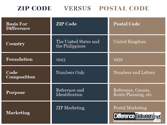
Difference between Zip Code and Postal Code
-
Country of Adoption
ZIP codes are highly adopted in the United States and the Philippines where specific numbers are allocated to different geographical locations and used as the reference method for individuals delivering mails and packages.
Postal codes refer to a numeric system that is used in other countries around the world except for the United States and the Philippines for easy identification of geographical locations for easy identification which helps in the prompt delivery of packages.
-
Introduction
Zonal Improvement Plan was introduced in early 1943 to help in easy identification of geographical locations in the United States.
The more advanced barcode was later formulated in 1963 to specifically help in identifying specific cities, homes, businesses, and other government bodies. The new model was formulated such that it would give a more precise identification of the location than the earlier model.
On the other hand, postal codes were introduced in the United Kingdom between 1959 and 1974 after which the codes were adopted in other English speaking countries. Postcodes have the primary role of designating a specific location with an address or a single primary delivery unit.
-
Formatting
The format of the ZIP code is such that the first digit represents a specific group of states in the United States. The second and third digits depict a region in the states highlighted in the first digit. Finally, the fourth and fifth digits represent a group of delivery addresses within a specific area.
The structure of the postal code is formulated such that one or two letters or digits are named after a local city or town. The second digit represents the district in that region which are finally followed by a space and finally an arbitrary code of one number and two letters.
-
Code Composition in Zip Code and Postal Code
There is a significant difference between the ZIP code and postal codes regarding their composition. A ZIP code contains numbers only since numerals have been used in identifying locations, businesses, private properties, and government parastatals in the United States.
A postal code constitutes both numerals and letters in the formation of a comprehensive address that is independent of other postal codes. Numbers and letters are used because they have been used in the identification of specific locations in English speaking countries.
-
Purpose of Zip Code and Postal Code
The purpose of ZIP codes in the United States and the Philippines is to identify different locations around the country to help in the delivery of mails and packages. The code is also used by security agencies to respond to emergency calls and other special needs.
Postal codes are not only used for reference in delivering packages but have also been used for other purposes which include designating destinations in route planning software, census enumeration, and calculating insurance premiums.
-
Postal and Zip Code Marketing
Current competition among different organizations has led to increased innovation where companies have been using postal codes and ZIP codes to reach out to their customers.
For example, companies have been using postal address to send letters and monthly magazines which have products of the company.
ZIP code marketing seems to be more profound and active due to competition in the country. Point-of-sale cashiers have been asking customers to give their ZIP codes which help to collect data that is essential in determining the location of new business establishments.
Difference between Zip Code and Postal Code

Summary of Zip Code and Postal Code
- ZIP codes and postal codes are numerical and letter systems that are used in identifying different geographical locations for easy and prompt delivery of mails and packages.
- ZIP code system is adopted in the United States and the Philippines for identification of private properties, business entities, and government agencies while postal codes are adopted in the United Kingdom and other countries around the world.
- Zonal Improvement Plan has been in operation since 1943 while at the same time receiving constant improvement while postal codes were introduced in 1959 in the United Kingdom which later spread to other countries around the world.
- The formatting and structure of the codes are different where ZIP codes contain numbers which are identified in different countries while postal codes have both different numbers and letters allocated to different locations.
- Difference Between Gross NPA and Net NPA - April 20, 2018
- Difference Between Job Description and Job Specification - April 13, 2018
- Difference Between Yoga and Power Yoga - April 10, 2018
Search DifferenceBetween.net :
Leave a Response
References :
[0]Krieger, Nancy, et al. "Zip code caveat: bias due to spatiotemporal mismatches between zip codes and us census-defined geographic areas—the public health disparities geocoding project." American journal of public health 92.7 (2002): 1100-1102.
[1]Lam, Louisa, and Ching Y. Suen. "Structural classification and relaxation matching of totally unconstrained handwritten zip-code numbers." Pattern Recognition 21.1 (1988): 19-31.
[2]Ng, E., R. Wilkins, and A. Perras. "How far is it to the nearest hospital? Calculating distances using the Statistics Canada Postal Code Conversion File." Health reports 5.2 (1993): 179-188.
[3]Image credit: https://upload.wikimedia.org/wikipedia/commons/thumb/5/5d/10005_zip_code.jpg/640px-10005_zip_code.jpg
[4]Image credit: https://commons.wikimedia.org/wiki/File:Postal_codes_of_Georgia.png#/media/File:Postal_codes_of_Georgia.png
